On Easter Monday this year I went looking for the Church of England Cemetery at Castlereagh, New South Wales. From Penrith, Castlereagh Road spears across the once fertile Nepean River flats that were divided into family farms by the first government land grants. These grants were given to former convicts and free settlers in the hope that their agricultural pursuits would provide food for the struggling, infant colony of New South Wales. Many of these early farmers are buried in the cemetery I was going to find.

These days when you drive across the flats, you look down onto large areas of land where masses of earth have been removed to shape future parts of the Penrith Lakes Scheme. This area is quarried for sand, gravel and river pebble. The Lakes Scheme is seen as land remediation. It has totally changed the natural and built landscape of this historic region.

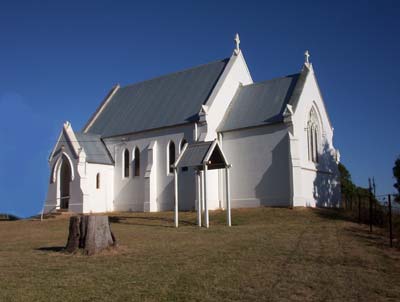
As you come into the present day district of Castlereagh, the white, glossy painted Christ Church glows on the rise above the river flats like a beacon. This church was built in 1878 after fire destroyed the school and church which were built originally for Henry Fulton, Castlereagh’s first parson.
Before all the changes to this area, it was possible to drive straight up Church Lane from Castlereagh Road to the church and then on to the cemetery. Now you have to test your navigational skills and drive further, before finding yourself back up on the rise in Church Street. The cemetery is in this street. Because it is unmarked and over run by trees and scrub, you have to look carefully to find it. It is surrounded on two sides by Crown Land. The cemetery is the only reminder left of “the Castlereagh” Governor Macquarie had in mind, when he announced his “Five Towns” in December 1810.

As part of a tour of inspection of the region, Governor Macquarie visited there in November 1810. He viewed the farms very favourably, but noted their perilous position when the river flooded. He attributed the “very mean and paltry” state of the residences to this constant threat. Leaving his carriage for horseback, he proceeded to “view the back line of Farms, and explore the Ground intended to be laid out shortly for a Township and place of security and retreat for the Settlers inhabiting this part of the Country”. He reckoned it to be not more than three miles from the river. Before returning to Sydney, he announced the names of his five new townships. This Nepean district was officially named Castlereagh, in honor of Lord Viscount Castlereagh. Macquarie recommended to those influential citizens of the district to begin encouraging the farmers “to lose no time in removing their Habitations, Flocks & Herds to these Places of safety and security”. These recommendations highlighted the Governor’s policy that land, especially fertile river flats, was to be exclusively used for cultivation and not for pasture. Considering the scarcity of land in the colony, using it for pasture was deemed wasteful and was not to be encouraged. However, despite these plans, the residents of the Nepean district preferred to stay where they were.
