JOURNAL OF A TOUR OF DISCOVERY ACROSS THE BLUE MOUNTAINS, in the year 1813, by Gregory Blaxland
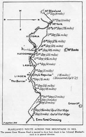
On Tuesday, May 11, 1813, Mr. Gregory Blaxland, Mr. William Wentworth, and Lieutenant Lawson, attended by four servants, with five dogs, and four horses laden with provisions, ammunition, and other necessaries, left Mr. Blaxland's farm at the South Creek 5, for the purpose of endeavouring to effect a passage over the Blue Mountains, between the Western River, and the River Grose. They crossed the Nepean, or Hawkesbury River, at the ford, on to Emu Island 6, at four o'clock p.m., and having proceeded, according to their calculation, two miles in a south-west direction, through forest land and good pasture, encamped at five o'clock at the foot of the first ridge. The distance travelled on this and on the subsequent days was computed by time, the rate being estimated at about two miles per hour. Thus far they were accompanied by two other gentlemen. 7
 On the following morning (May 12), as soon as the heavy dew was off, which was about nine a.m., they proceeded to ascend the ridge at the foot of which they had camped the preceding evening. Here they found a large lagoon of good water, full of very coarse rushes. 8 The high land of Grose Head 9 appeared before them at about seven miles distance, bearing north by east. They proceeded this day about three miles and a quarter, in a direction varying from south-west to west-north-west; but, for a third of the way, due west. The land was covered with scrubby brush-wood, very thick in places, with some trees of ordinary timber, which much incommoded the horses. The greater part of the way they had deep rocky gullies on each side of their track, and the ridge they followed was very crooked and intricate. 10 In the evening they encamped at the head of a deep gully, which they had to descend for water; they found but just enough for the night, contained in a hole in the rock, near which they met with a kangaroo, who had just been killed by an eagle. A small patch of grass supplied the horses for the night.
They found it impossible to travel through the brush before the dew was off, and could not, therefore, proceed at an earlier hour in the morning than nine. After travelling about a mile on the third day, in a west and north-west direction, they arrived at a large tract of forest land, rather hilly, the grass and timber tolerably good, extending, as they imagine, nearly to Grose Head, in the same direction nearly as the river. They computed it at two thousand acres. Here they found a track marked by a European, 11 by cutting the bark of the trees. Several native huts presented themselves at different places. They had not proceeded above two miles, when they found themselves stopped by a brushwood much thicker than they had hitherto met with. This induced them to alter their course, and to endeavour to find another passage to the westward; but every ridge which they explored proved to terminate in a deep rocky precipice; and they had no alternative but to return to the thick brushwood, which appeared to be the main ridge, with the determination to cut a way through for the horses next day. This day some of the horses, while standing, fell several times under their loads. The dogs killed a large kangaroo. The party encamped in the forest tract, with plenty of good grass and water.
On the next morning, leaving two men to take care of the horses and provisions, they proceeded to cut a path through the thick brushwood, on what they considered as the main ridge of the mountain, between the Western River and the River Grose; keeping the heads of the gullies, which were supposed to empty themselves into the Western River on their left hand, and into the River Grose on their right. As they ascended the mountain these gullies became much deeper and more rocky on each side. They now began to mark their track by cutting the bark of the trees on two sides. 12 Having cut their way for about five miles, they returned in the evening to the spot on which they had encamped the night before. The fifth day was spent in prosecuting the same tedious operation; 13 but, as much time was necessarily lost in walking twice over the track cleared the day before, they were unable to cut away more than two miles further. They found no food for the horses the whole way. An emu was heard on the other side of the gully, calling continually in the night.
.

